Into the Woods: Arkaquah Trail

Walking up and down hills is the cost of doing business in hiking. In essence, that is hiking; the exercise, the views, the solitude, and the experience all flow from it. If it was easy to get to where a hiking trail goes, there would be a road, right?

Sometimes, the particularly dedicated (or disturbed) among us thumb our noses at perfectly good roads in favor of the hike. For instance, in the eastern U.S., many high mountains are accessible by car for the tourist value. Such is the case with Georgia’s Brasstown Bald. At 4,784′, it’s nowhere close to the tallest peak in Appalachia, but it is the tallest in its state. It is also fairly disconnected from other nearby peaks, with a prominence of nearly 2,200, making for unobstructed long-range views.

The way most people enjoy Brasstown is by a drive up GA 180 Spur and then a quick shuttle ride to the summit. You can pay the USFS $5 a pop for the privilege, and then enjoy the cool breezes in a rocking chair under the observation deck. I’ve driven up at least a few times myself. Then, there’s the other way….

A good friend from Pennsylvania has taken up highpointing, and he wanted to tackle Brasstown during a visit to the Atlanta area, so I headed over to meet him Saturday in Blairsville (just shy of 2 hours’ drive from Chattanooga). Part of the joy of his project is a refusal to do things the easy way, so driving to the summit is out. After doing our research, we decided on the Arkaquah Trail, which begins at almost exactly 2,200′ above sea level at Track Rock Gap.

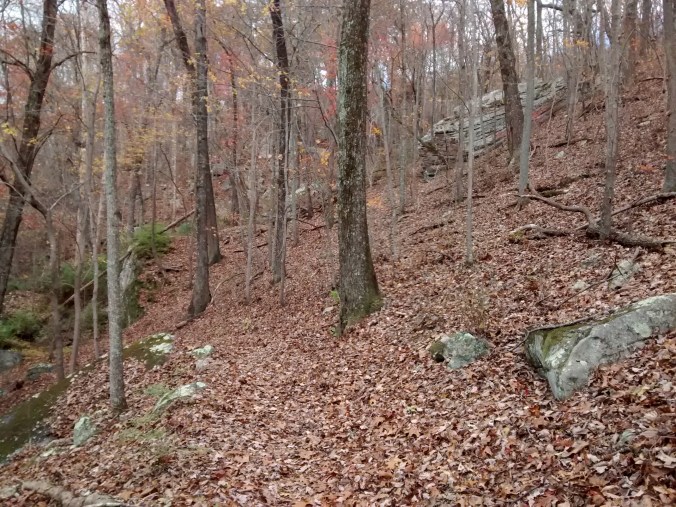
This 5.5 mile trail (at least that’s what the sign says, we measured it at just over 5.2) traverses a large roadless area in Chattahoochee National Forest’s Brasstown Wilderness before spitting you out at the main parking area just below the top of Brasstown Bald. If you do the math, that’s a 2,784′ gain over the distance, or about 500′ per mile; not too harsh. The kicker is that the first 1.2 miles pack in 1,400′ of that gain. That’s a 22% grade, folks; by comparison, a steep highway descent with runaway truck ramps might be 7-8%.

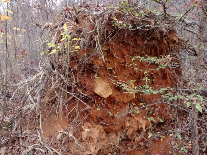
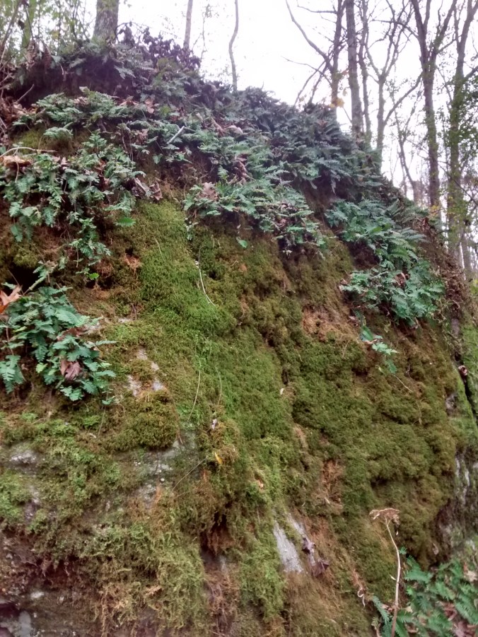
Going up, we muscled through the climb, knocking out the first two miles in just under an hour through no small amount of huffing and puffing. After that, the second two-thirds of the trail made for a nice walk to enjoy the scenery, replete with Southern Appalachian standards (blue mountain vistas, rock outcrops, rhododendron tunnels, wildflowers, wildlife, etc.). We even saw a bear (on the way back down), which is less fun than it sounds when you’re three miles from your car. The only hiccup was a very large tree across the entire trail that required some, shall we say, “wrestling” to get past.

The last 0.6 mile is almost as steep as the first bit, but it’s the paved walk-up to the summit from the parking lot. Finishing strong is easy when you’re being goaded on by grannies and toddlers with fresh legs.

And then there was the descent.

You would think that the uphill leg is the more difficult, but my knees and hips now beg to differ. By the time we got into the car, walking was painful. Even standing was slowly becoming difficult. Driving home took just long enough for complete rigor mortis to set in. Teaching Sunday school the next morning was only facilitated by shameless leaning on the podium. The blisters on my heels are only just now healed. The stuffed mushrooms, beer, and burgers at trail’s end would’ve gone down even better with a little ibuprofen.

Looking back, the most remarkable thing about the whole experience was that we stayed dry. I have almost never been on a long hike in the summer that didn’t involve an abject downpour. To be fair, it tried to sprinkle a bit here and there, but this summer’s drought won the round.

Crazy? Sure. But once you’re around the bend, you may as well keep at it. Voluntary pain & suffering notwithstanding, a trip like this is always a rich and fruitful therapy for my soul.

Into the Woods: Conasauga Lake and Grassy Mountain

Location is everything.

Chattanooga is where it is because of the conveniences of transportation. It’s where the Tennessee River cuts through the wall of the Cumberland Plateau, and the city built up around this natural intersection between boats and rails during the early industrial era. That made it quite the prize during the war between the states, and it’s the crossroads of the South even still—a 2.5 hour drive or less from Atlanta, Knoxville, Birmingham, and Nashville. Much of the traffic between the Southeast and the Midwest passes through here, giving us more traffic woes than a city of this size warrants. Two of the top 10 largest trucking corporations in the U.S. are headquartered here, and we’re still known around the world for a catchy tune about a train ride.

All of that to say, living here makes getting other places a fairly easy proposition, so much so that a drive over to the western edge of the Appalachians for a day hike isn’t much trouble at all. On clear days from certain vantage points around town, you can make out the profile of Big Frog, Cowpen Mountain, and Grassy Mountain shooting up from the valley floor about 40 miles to the east. They are the westernmost “real mountains” (+/- 4,000 ft. above sea level) in the country until you get to the Black Hills.  Continue reading

Into the Woods: Lula Lake

Winter is my favorite season.

The snow. The cold. The wind. I’ll take it all with a smile.

Now, before the haters descend (who are these poor epithets of opinion anyway?), the “winter” I get to enjoy here in Chattanooga often looks a lot like what people in Minnesota might call “July”. Winter for us has occasional elements recognizable to folks further north, but mostly it is the time of year when the humidity goes down, the bugs die or evacuate, and the grass (mercifully) stops growing for a bit. To put it another way, if you wonder why Tennesseans and other species of Southerner delight in winter, come spend August with us sometime. You’ll be yearning the relative comfort of a blizzard within a week.

Case in point: Saturday. It was 29°F at sunrise, without a cloud in the sky. By mid-afternoon, it was up to 65. I’m hard-pressed to think of a better all-around day to spend outside, and the climate of this part of the world presents an embarrassment of these riches from November to March. Faced with such finery, I naturally went hiking.

IMG_4878Being the last weekend of the month, it was an open-gate day at Lula Lake Land Trust. This privately owned plot of 8,000 or so acres is on the east side of Lookout Mountain (part of the Cumberland Plateau) in Walker County, Georgia, about 5 miles south of the Tennessee Line.

Like much of the plateau eco-region, the property features mature oak forests that thrive on the relatively poor, thin soil overlaying the mountain’s cap rock. These give way to a lush riparian zone along the course of Rock Creek through the middle of the trust’s land, with Hemlock, Rhododendron, Mountain Laurel, Ferns, and other species that need more moisture to thrive. I’ve been visiting this spot for several years, and the diversity of plants and terrain in such a small area makes it a special place indeed. The trust seems to know well what a treasure they have in their hands, and their careful management of the tract promises to keep it just as pristine for years to come (in fact, its current state is largely due to the founder buying up land to redeem it from logging and abuse).

For this trip, I had neither kids in tow nor a time limit, so I set out to explore some trails I hadn’t been able to get to yet. There are over 7 miles of trails in the section of the property that is open to visitors, in addition to the gravel road bed that runs along the creek (part of which is the way vehicles get in and out). All are very well signed, and the varying degrees of difficulty should keep any level of hiker satisfied with a visit. Continue reading

Into the Woods: Home

Carving out time for hiking, valued though it is, often takes quite the effort. Because of this, I am always very grateful for the Lookout Mountain segment of Chickamauga and Chattanooga National Military Park. When you have 3 hours for a hike, 30 minutes (round trip) in the car and 2-and-a-half hours on trail is far preferable to driving a long way for a short walk.

In thick irony, all of the peaceful parkland around our city is only here because the violent deaths of several thousand men on these grounds in 1863. There is room for reflection there (of which more another time) which does not go unnoticed, but we locals love the battlefields for the 9,000+ acres of public land they afford. My kids are growing up with this heritage, and they already probably think it’s odd that you don’t have cannons all over the place where you live.

I’ve trod many a mile around this old mountain, handy as it is (much of it  within Chattanooga’s city limits). Trucks and trains rumble just beyond the park’s edge, and there are two fully functioning towns (Both conveniently named Lookout Mountain—one in Tennessee, one in Georgia) atop the plateau, but the trails quickly open to mature forest.

Yesterday, Rachel & the older two girls had a birthday party to attend, so I “volunteered” (read: begged) to watch the youngest and spare us the experience. It was nice out (this fall as been terribly warm), so we decided to head for the woods.

IMG_20151121_140059118

Selfies are not my forté, but at least toddlers in backpacks are cute.

We parked over on the west side of the mountain off Wauhatchie Pike  (near the Chattanooga Nature Center), to go upslope via the Kiddie trail (named for someone, not made for kids)/Skyuka Springs Trail/Gum Springs Trail. Time (and the limited patience of strapped-in children) kept us from making it all the way to Sunset Rock, but we were headed in that general direction.

IMG_20151121_142107786

Kiddie is not terribly scenic, just a steep access path into the rest of trail network. A number of downed trees (probably dating from a bad tornado outbreak a few years ago) left the canopy spotty enough that the lower trail is rather overgrown and weedy.

IMG_20151121_141125581

Further up, there were still a few fall colors poking through, and plenty of the usual Cumberland Plateau scenery (boulders, oaks, streams, etc.).

IMG_20151121_140822190

IMG_20151121_142451637

IMG_20151121_143303146

IMG_20151121_145933501_HDR

As an aside, this area always makes for some interesting plant finds (like the Japanese burning bush shown below). Homeowners on the brow of the mountain above must toss their yard waste over the cliffs, and enterprising seeds and shoots take root in the woods below. A lot of what you see growing down there does not “belong”.

IMG_20151121_144342634

A few miles of foot-pounding does a body (and soul) good, but I’m not certain my passenger felt the same. She didn’t cry, though she did hold on to my shoulder for most of the ride; for her first time in the backpack, I suppose she thought she was “floating” behind my head and not entirely confident of her situation. It’s the price you pay for being my kid, I guess.

IMG_20151121_143333157